![]() Voluntary citizens' group
Voluntary citizens' group
"I mati dela Sorna" of Brentonico
No address or telephone number
Please refer to the author
(the logo is by the painter Aldo Ripamonti)
![]() Voluntary citizens' group
Voluntary citizens' group
"I mati dela Sorna" of Brentonico
No address or telephone number
Please refer to the author
(the logo is by the painter Aldo Ripamonti)
Monte Baldo and the environment of Lake Garda Trentino are now famous and visited by thousands of tourists from all over the world. The reasons are that the area offers a mild, almost Mediterranean climate in all seasons of the year. Another reason is the fact that Mount Baldo offers a large number of endemic flora and fauna. Finally, not to be underestimated is the excellent range of tourist facilities and typical Italian catering. Of course, there has been a large network of trails on Mount Baldo for centuries, which allow all types of trekking practically all year round and are very popular. In less touristy areas, there are also traces of equally historic and scenic trails that are completely unknown. We have gone 'on the hunt' for these trails, cleaned and marked them, and now present them to you on these pages.
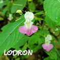
 NEWS - Along the Lodron stream at Pont del diaol
Easy trek along the new path along the Lodron stream to the famous Pont del diaol. Traverse following the Sorna torrent
and up the characteristic Senter dele Val. This is the easiest route in the Sorna riverbed.
length: 3.1 km - diff-alt: 150 m - durata: 2.00 h
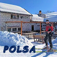
 Polsa di Brentonico Monte Baldo
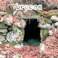
From the tourist resort Polsa descent to the wild Valle dei Albi and traverse to the village Al Mont di Saccone.
Visit to the historic locality of Bracon and return via the Malga Cestarelli road.
length: 9.2 km - diff-alt: 400 m - duration: 4.00 h
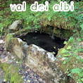
 Albi Valley from the village of Saccone
A lonely valley where there is still a historic spring that has watered men and animals for centuries.
It is located near the ski slopes of Polsa di Brentonico. The trek takes place first on a fairly steep path and then on easy forest roads.
length: 10.5 km - diff-alt: 600 m - duration: 4.30 h
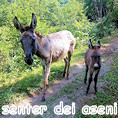
 From Chizzola to Tragno, first part of the Sorna canyontrek
You walk through a first part of the Sorna torrent gorge. The route is adventurous and involves passages facilitated by
chains and three fords. A minimum of experience on mountain trails is required. One ascends to Tragno via the ancient 'Senter dei Aseni'.'
length: 3.8 km - diff-alt: 210 m - duration: 3.0 h
 Senter dela Bancheta from Festa di Brentonico
A path through the forest of Monte Baldo on the traces of the First World War. A visit to the war posts with a beautiful panorama
over the Brentonico plateau to the Adige valley. Steep but well-marked trails in an ancient beech forest.
length: 5.7 km - diff-alt: 540 m - duration: 4.0 h
 The first dwelling houses at the foot of Monte Baldo
An interesting archaeological discovery consists of the first human settlements of shepherds on Monte Baldo Trentino. It is
amazing to see how our ancestors lived in a scenic and peaceful place. The climb takes place on the famous 'peace trail'.
The return on forest roads.
length: 8.0 km - diff-alt: 420 m - duration: 4.0 h
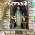
 The First World War fortress and the Madonna della Crona on Mount Cornale'
A loop tour on the paths of Monte Cornale' allows you to visit both the First World War fortress and the unknown sanctuary
of the 'Madonna della Crona'. It takes place on easy, sometimes steep paths and along the many trenches of war.
length: 5.9 km - diff-alt: 230 m - duration: 3.30 h
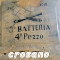
 Visit to First War emplacements close to the village of Crosano. Return for the Cross Tour
A loop hike on the paths of Monte Baldo allows you to visit the First World War emplacements
and the silvopastoral environment typical of Trentino. It takes place on easy paths.
length: 4.4 km - diff-alt: 170 m - durata: 3.0 h
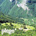
 From the Piagu' to the historic 'Corno della Paura' peak
Another unknown area of Monte Baldo. The Piagu' plateau is a paradise on earth where humans and animals coexist in harmony.
The summit of Corno della paura is famous for the events of the First World War. One of the passages of the route is difficult
and involves climbing a steep edge for approx. 50 m.
length: 7 km - diff-alt: 650 m - duration: 4.30 h
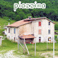
 From Saccone via the 'Senter dela Scaleta' to Piazzina,
ascent to Pozza village and return via Val dei Berti
A wide-ranging route involving forest roads and the ancient 'Senter dela Scaleta', which is today in disuse. Almost all of
the trails that are followed were built by soldiers in the First World War.
length: 8.6 km - diff-alt: 530 m - duration: 4.00 h
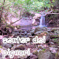
 The most interesting place in the canyon of the Sorna torrent.
Ancient bridges, high waterfalls and vestiges of old mills.
Access is near the village of Cornè and then in twenty minutes you reach a fascinating natural site. On the ascent the
'Senter dei Pignari' presents some difficulties and several fords.
length: 3.6 km - diff-alt: 230 m - duration: 3.00 h
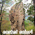
 Saiori Castle an ancient manor full of history and legends
A fairytale place where history and legends intertwine over the centuries. It is easily reached from the village of Cornè,
but we tried to reach it from the unknown path that starts in the Adige Valley from the village of Santa Lucia.
length: 7.1 km - diff-alt: 500 m - duration: 4.30 h