![]() Voluntary citizens' group
Voluntary citizens' group
"I mati dela Sorna" of Brentonico
No address or telephone number
Please refer to the author
(logo by Aldo Ripamonti)
![]() Voluntary citizens' group
Voluntary citizens' group
"I mati dela Sorna" of Brentonico
No address or telephone number
Please refer to the author
(logo by Aldo Ripamonti)
We had heard of a path up the Adige Valley to Saiori Castle. Leaving aside the legends of tunnels from the village of
Chizzola up to the castle that were used to carry water on donkeys, etc.etc. It seemed to us the shortest and most logical route up to the
castle, but the people we asked could not give us any indication. That there was an ancient unknown path on the slopes of Monte Baldo only
increased our curiosity. We had seen a track on some old map of the Austro-Hungarian Empire and finally, in the spring of the year 2022, we
set out to discover the path, of course equipped with GPS. We had found a trail on the DAV maps, probably copied from some World War I map,
and we decided to follow the trail.
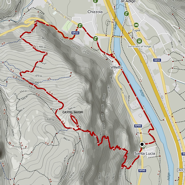
Ruins of the boundary wall of Saiori Castle
In the village of Santa Lucia, immediately after the locality of Chizzola, the provincial road passes through a bottleneck
between the houses; here there is a small widening on the left, intended as a playground, and a small car park; there is also a fountain
with drinking water. At the the bottleneck, carefully cross the provincial road and take a small agricultural road uphill. After about 200
metres the road gets lost in the forest and you notice a space where farm tractors turn around, but... no trace of a path! Convinced that we
must once again go trekking in the middle of the jungle, we put our hands on the GPS and, following the DAV trail, we finally found a convenient
path. The beginning of the trail was obscured by branches; we will never understand why the farmers in the villages do not tolerate the passage
of 'outsiders' (=foreigners) on their territory to the point of obliterating access to the ancient paths in their territories. Proceeding along
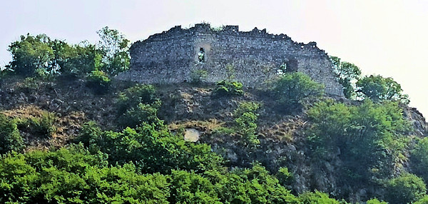
the half-hike path after about 10 minutes of walking, we found some tunnels and emplacements dating back to the First World War. Surely the
place had a strategic defence position over the entire Adige Valley; the nature of the emplacements is similar to the typical forts of Austrian
soldiers. We proceed uphill, quite steeply, on a well-marked path with some hairpin bends. Finally, we reach a small road that leads to a meadow
flat meadow below the slopes of Saiori Castle and a path leads to the top of the hill where we can admire the poor remains of the castle.
We have covered a elevation difference of about 500 metres and observing our route on Outdooractive we notice a surprising coincidence with the
path shown on the DAV map. Now it is a matter of descending back to the valley and we follow the forest road to the north that leads to Corne', the
road runs alongside a brand new wine-growing plant. After about twenty minutes of walking, we finally see a sign indicating "Chizzola" and follow
the easy downhill path that leads directly onto the provincial road 22 known as Madrera. At the hairpin bend of the cross, we continue to the right
on a path until it joins the provincial road again, just above the village of Chizzola. Cross the village and, having reached a crossroads, you
will find a refreshment point with excellent sandwiches and even pasta. At this point, cross the provincial road right Adige and take a tedious
but safe cycle path that takes us back to Santa Lucia.
WARNINGS It is not advisable to climb up to Saiori Castle in the summer as the path is all exposed to the east and therefore to the
morning sun. The path that leads from the meadow below the cliff to the castle was restored and made safe by the Autonomous Province of Trento,
now (2022) it is in very poor condition and requires attention.
On the path up to Saiori Castle, countless remains of fortifications from the First World War
True stories and legends have been woven about the castle for centuries, but no one has ever investigated the real vicissitudes
of this place and the adjacent Piazzina plateau. I myself was commissioned to briefly explore the history of this fantastic castle with the
prerogative that 'You can find everything on the Internet anyway', nothing could be more inaccurate. Equally astonishing is the fact that no one
in any ancient era has recorded even a written record, nor a document, nor deposited in any library information, about this fantastic place.
There exist among the population only legends handed down from father to son, historical memory is lost in supposition until at least the year 1400.
Given the considerable strategic importance of the fortress for the control of the Adige Valley, it is assumed that the place was already the site
of forts by the Lombards.
The only certain historical information can be found in Luigi Zenatti's book 'La contessa verde di Brentonico' (The Green Countess of Brentonico).
Luigi himself told me that he was writing a book, concerning Castel Saiori, which had cost him twenty years of historical research and several
visits to the library in Bologna, the city birth place of the protagonist of his book. The legend of the 'contessa verda' whose ghost roams on
horseback around Castel Saiori moonlit nights has finally had historical confirmation. The date of the countess's death on 2 September 1364 is
the first certainty in the history of Castel Saiori. Viridia Piepoli, as the woman was called, originally from Bologna, had married Count Giovanni
II of Castelbarco. It is assumed that Giovanni himself had, in the years before, provided for the renovation of the castle that so pleased his wife.
The history of the following centuries, although fragmentary, is nevertheless proven by historical documents.
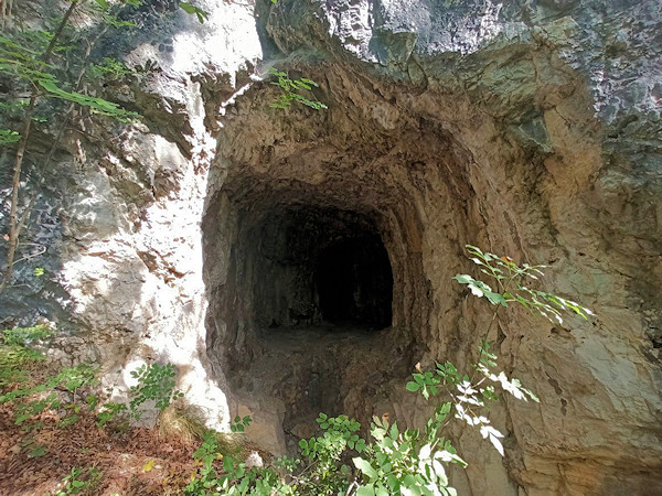
An ancient watering hole near Saiori Castle has existed for thousands of years
WARNING - The group of volunteer citizens called 'I mati dela Sorna' has worked hard to make the trek as safe as possible. Keep in mind that Monte Baldo is still a mountain and, as with all excursions in an alpine environment, it is not absolute safety cannot be guaranteed.
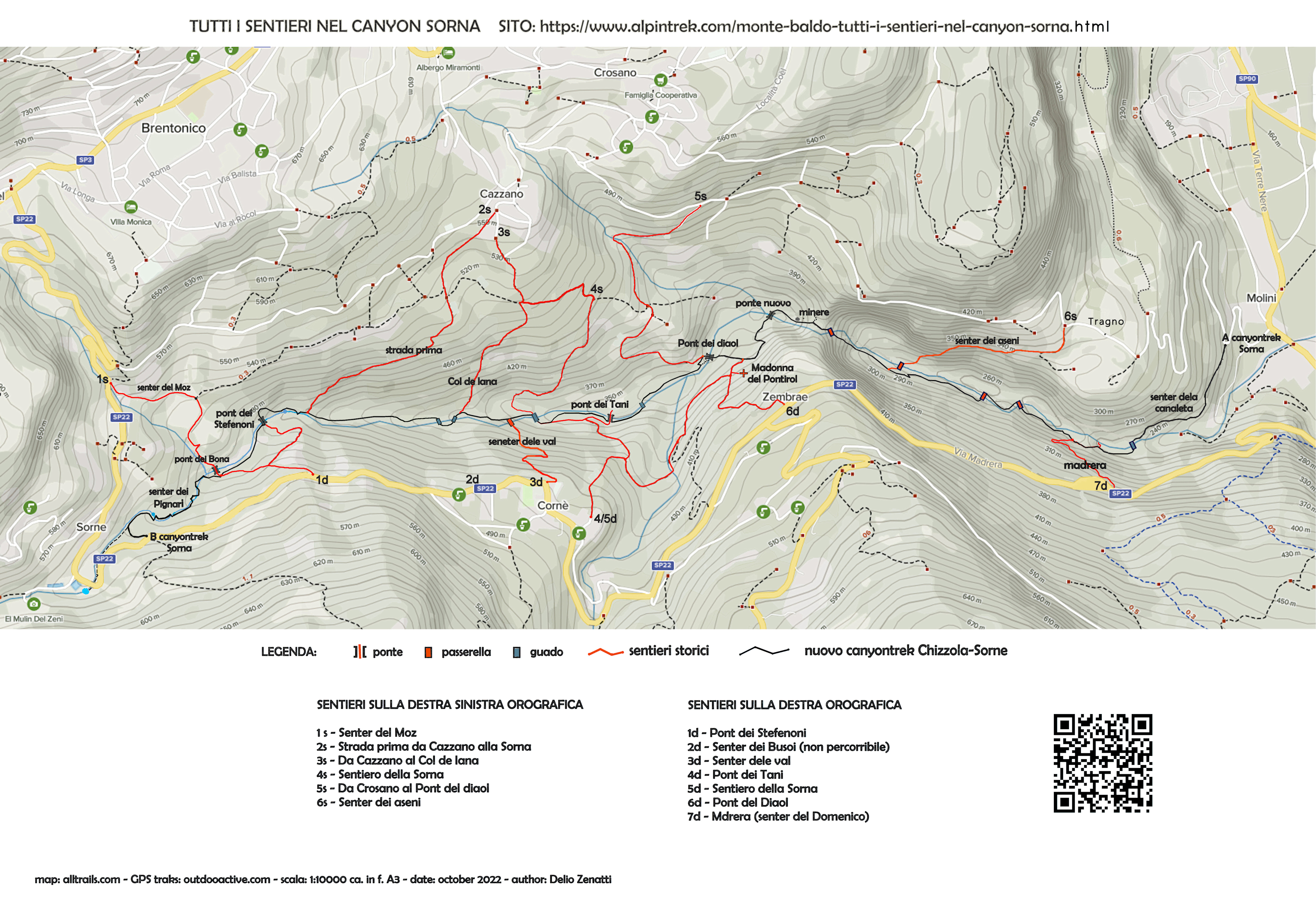
MONTE BALDO TUTTI I SENTIERI NEL CANYON SORNA - MAP CANYONTREK SORNA
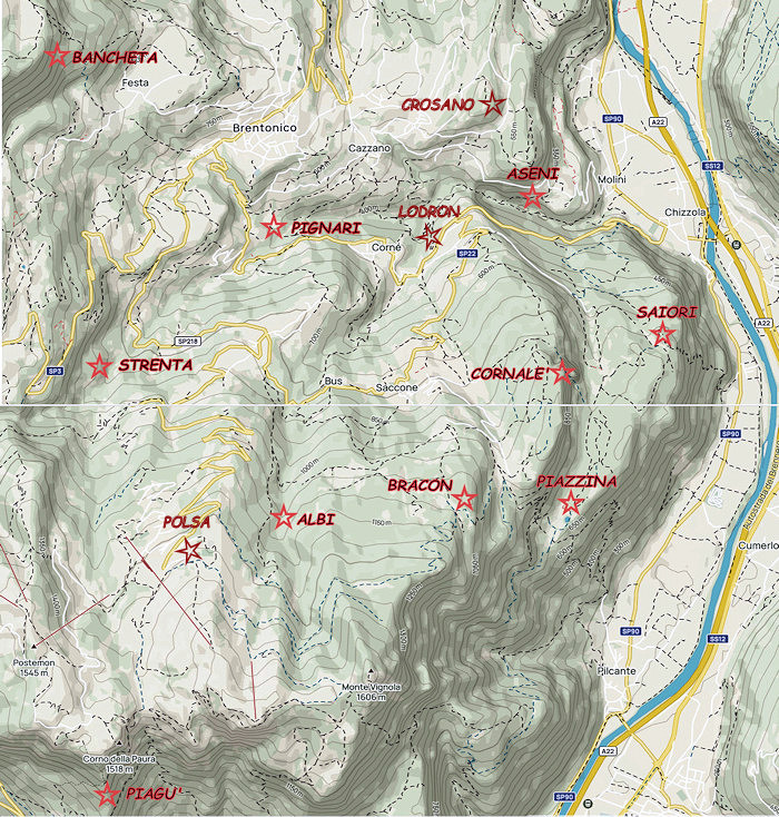
UNKNOWN PATS ON MONTE BALDO - SENTIERI SCONOSCIUTI SUL MONTE BALDO
CORNALE' - BANCHETA - PIGNARI - BRACON - ASENI - SAIORI - PIAGU' - PIAZZINA - ALBI - CROSANO - POLSA - LODRON
SOURCES - From outdooractive.com, you can also download the gpx file of the route.
Web site https://out.ac/ICWTjc
Alltrails.com maps - Delio Zenatti's gps tracks on outdooractive.com