![]() Voluntary citizens' group
Voluntary citizens' group
"I mati dela Sorna" of Brentonico
No address or telephone number
Please refer to the author
(logo by Aldo Ripamonti)
![]() Voluntary citizens' group
Voluntary citizens' group
"I mati dela Sorna" of Brentonico
No address or telephone number
Please refer to the author
(logo by Aldo Ripamonti)
The route is short but not easy from a technical point of view due to a few passages facilitated with chains and the three fords
indispensable. It can be classified as EE (experienced hiker). There are no excessive dangers, but it does require appropriate footwear and some
experience on mountain trails.
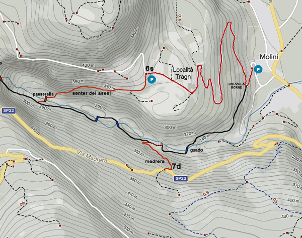
The first part follows the "canyontrek Sorna" to a footbridge that replaces the old "Pont dei aseni", while the ascent takes place on the path
of the same name until reaching the locality of Tragno; the return is on an asphalt road until returning to the locality of Molini di Chizzola.
Coming from the exit Rovereto Sud motorway exit, follow the provincial road to the right Adige until you reach Localita' Molini, take the municipal
road on the right that goes up to the village of Cazzano di Brentonico. After the first hairpin bend there is a small parking area on the left
(max. 3 cars), please do not park in the field opposite. Go up the asphalt road for about a hundred metres and turn left onto a dirt road that
climbs slightly uphill and follow the path for approximately 900 metres until you reach the "Briglia della canaletta". Please do not follow the
path of the gully because it is exposed and dangerous.
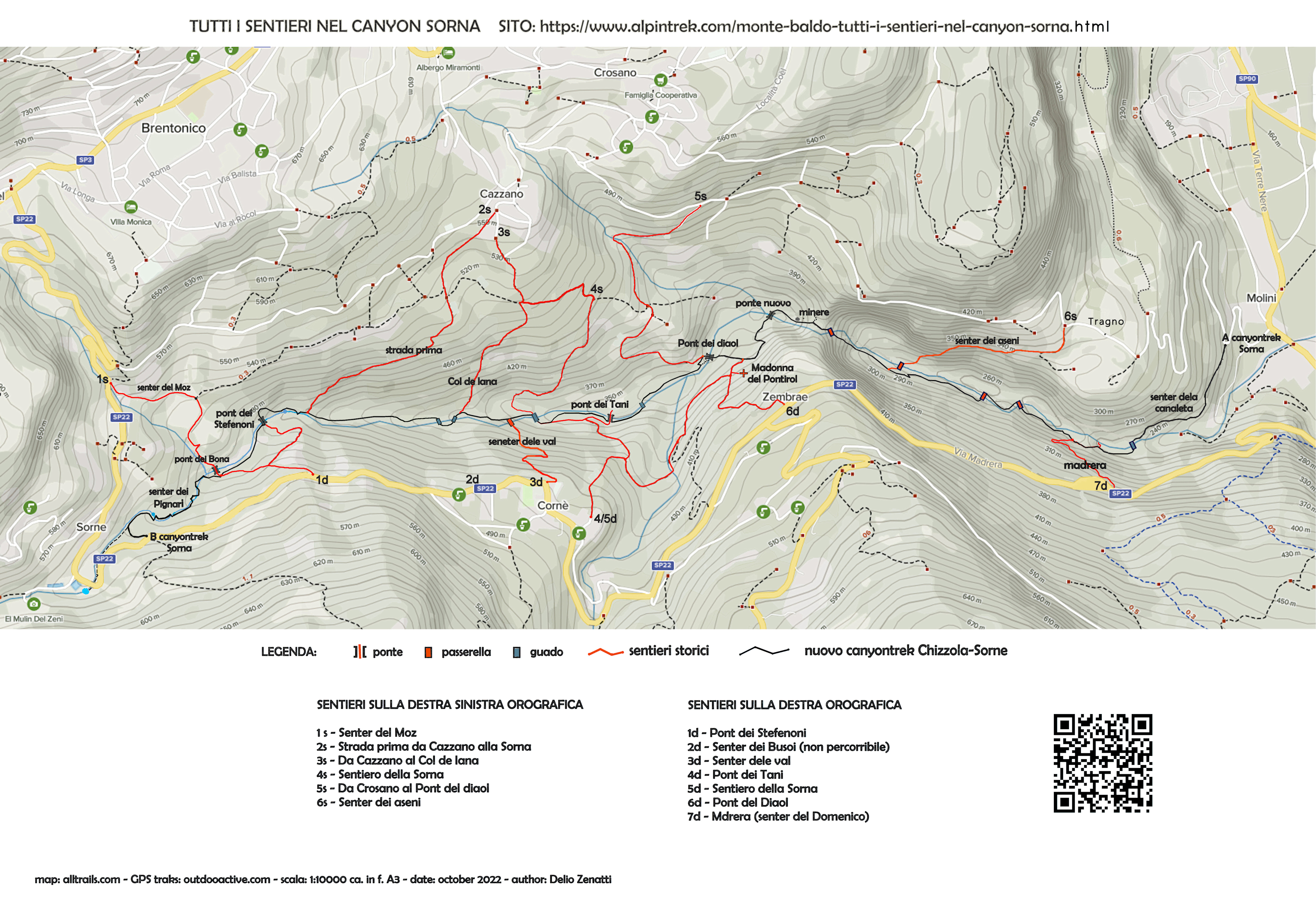
The Canaleta bridleway is the gateway to the Senter dei Aseni
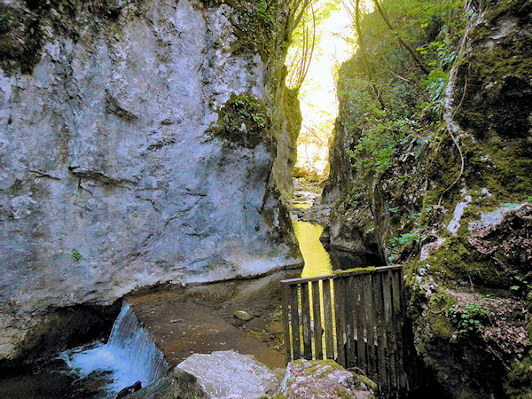
The bridleway is basically the water intake of the canal that has fed the Chizzola countryside for centuries. It is a
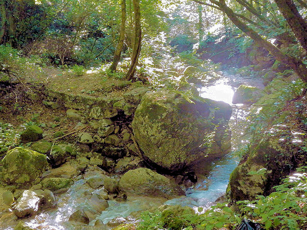
characteristic place but the gorge of Sorna, wedged between two rock walls and the overhanging wall on the other side of the valley, instil some
awe. A slight rise in the terrain allows you to take very significant photos of the place, after which you can admire the steep gully that rises
to the left of the gorge, that is your path. The gully was equipped with an old rope, recently (October 2022) a long chain was installed
that allows you to ascend easily. No danger but the chain, installed at the care and expense
of the Autonomous Province of Trento, turns out to be of great help in the event of damp ground and/or foliage. We recommend crossing the stream
immediately downstream of the waterfall. It is essential to cross the stream from the bridleway; if you have waterproof shoes, you can easily
wade immediately downstream of the waterfall, where the water rarely reaches a height of 10 cm. Otherwise, further downstream, there are large
boulders on which to rest your feet, but they are often slippery, in any case poles are a great help. As usual, the presence of water is decisive
for the difficulty of the fords, to be be avoided in any case of flooding of the torrent.
After the traverse, you ascend the gully laboriously, with the aid of the chain, until you reach a very scenic knoll. Here you meet the dirt
road that descends from the Madrera and turn left, upstream; the road was built many years ago for the purpose of cutting wood and descends
from the provincial road to the Sorna riverbed. Follow the road slightly uphill for about 100 metres, where it flattens out look carefully
towards the valley until a barely visible path descends again towards the Sorna. A short steep slope leads to a small knoll, after which you
descend again to the stream, which requires another ford that is a little more difficult than the first (see white marks on trees and stones).
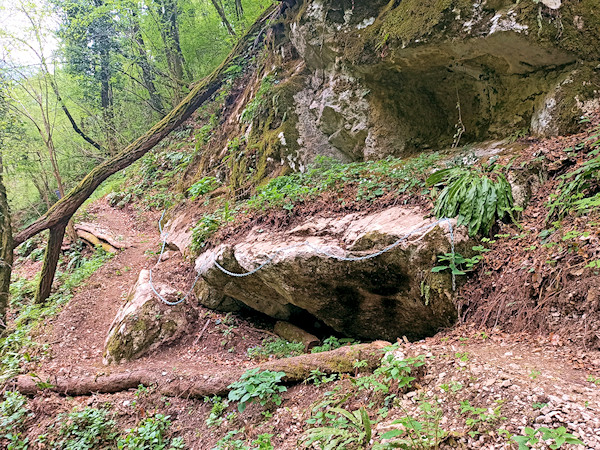
Sometimes the path was completely reconstructed and facilitated passage by chains
An easy level path leads to a slightly sloping rock slab that can be slippery and it is convenient to follow the marked path a little higher up. You reach a short traverse on rock ledges about half a metre above the line of the stream; a chain and stirrups serve only to facilitate the passage. Immediately afterwards, the third and last ford of our hike leads again on the orographic right bank, where we initially follow a complex path between the boulders and then on level ground on a track laboriously carved into the side of the valley. Here there are chains that allow you to cross safely even on wet ground. In a few minutes you have come in sight of the 'Pont dei Aseni', which you can no longer see: the bridge was destroyed by the 1967 flood, caused by the failure of a dam in Localita' Mosee in San Valentino di Brentonico. We have made requests to the competent bodies for the reconstruction of the bridge, but we always received negative replies until we decided to avoid another long and difficult ford by building two solid footbridges.
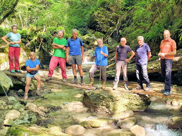
The 'Mati del la Sorna' group during the construction of the footbridges
Once past the chain path, keep an eye on the stream bed until you see the two footbridges. Descend on a comfortable path to the Sorna, one passes easily on the left bank under a rock wall. Here begins the actual 'Senter dei aseni', which climbs in about twenty-five minutes until reaching the Tragno locality. You reach a shrine, dedicated to Saint Valentine, located on the municipal road that descends towards Chizzola; here there is also a small car park which can hold three cars. Go down the municipal road for about 1.5 km until you reach your vehicles again.
The pont dei aseni as it looks today destroyed by the 1967 flood
It is interesting to learn about the origin of the road system along the Sorna Torrent. In the 1920s, the Italian government decided to start quarrying coal from the mines in the stream bed. It was not the old mines that can be visited today on the orographic left, but rather a new deposit on the orographic right of the Sorna, practically under the village of Zembrae, today inaccessible. The mines were never productive, the initiative was only aimed at providing some work for the poor local population, exhausted by the war. immediately called them the 'Mines of the Duce'. The problem of transporting the coal downstream arose and an existing mule track was used for this purpose. mule track that led downstream, the 'Pont dei aseni' was built, as well as the uphill mule track towards Tragno that today constitutes our 'Senter dei aseni'. In the village of Tragno, an area was set aside for the storage of coal, still called the 'Carbonaia', and from here the material was transported to the valley with tractors. The mines and their infrastructure soon fell into the oblivion of history until, in the year 2015, as part of the municipal initiative 'Adopt a path', some diligent citizens of Crosano took care of the restoration of the historical 'Senter dei aseni'. Unfortunately, the path went directly into the stream bed and, lacking the bridge, did not offer any development of path. In order to prevent everything from falling into oblivion and, given the impossibility of rebuilding the bridge, we recently decided (summer 2022) to install the footbridges. No one can guarantee that our solid footbridges will withstand future floods, in the event that they are destroyed by floods, it is necessary to transit as before, i.e. via fords.
WARNING - The group of volunteer citizens called 'I mati dela Sorna' has worked hard to make the trek as safe as possible. Keep in mind that Monte Baldo is still a mountain and, as with all excursions in an alpine environment, it is not absolute safety cannot be guaranteed.
MONTE BALDO TUTTI I SENTIERI NEL CANYON SORNA - MAP CANYONTREK SORNA
UNKNOWN PATS ON MONTE BALDO - SENTIERI SCONOSCIUTI SUL MONTE BALDO
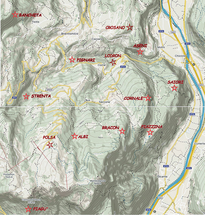
CORNALE' -
BANCHETA -
PIGNARI -
BRACON -
ASENI -
SAIORI -
PIAGU' -
PIAZZINA -
ALBI -
CROSANO -
POLSA -
LODRON
MADONA DELA VECIA
SOURCES - From outdooractive.com, you can also download the gpx file of the route.
Web site https://out.ac/IHoXKO
Alltrails.com maps - Delio Zenatti's gps tracks on outdooractive.com