![]() Brentonico voluntary citizens' group
Brentonico voluntary citizens' group
"I mati dela Sorna" of Brentonico
No address or telephone number
Please refer to the author
(logo by Aldo Ripamonti)
![]() Brentonico voluntary citizens' group
Brentonico voluntary citizens' group
"I mati dela Sorna" of Brentonico
No address or telephone number
Please refer to the author
(logo by Aldo Ripamonti)
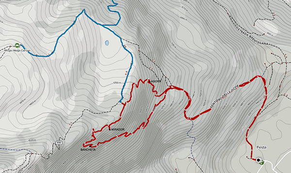
Park in front of the Festa playground. Initially, follow the SAT 650 path, also known as the 'Sentiero delle oche' for about 40 minutes. At a fork in the path, turn left and you will soon reach the notice board indicating the route. Take the path to the right and, in about 20 minutes, you will reach the 'Agora': this is a First World War post with a plateau, where there are benches, and a characteristic cave that served as an observatory. We climb the steep slope above until we reach the ridge dividing the valley from the malga plateau and reach the highest point of our route (1440 m). This is a vantage point called MIRADOR, with a view of the entire Adige Valley and the Brentonico Plateau. Downhill and a traverse we reach the famous 'bancheta' which has also recently been equipped with a table, and is the ideal place for a snack. Follow the path downhill, mainly northwards, until you reach the initial notice board and then follow trail 650 back to the car park. The entire route is well marked with a logo in the pictures and with stone "cairns". Caution is recommended for those wishing to visit the tunnel of the war observatory, located adjacent to the 'Agora'. The place is reached by climbing on easy but exposed rocks.
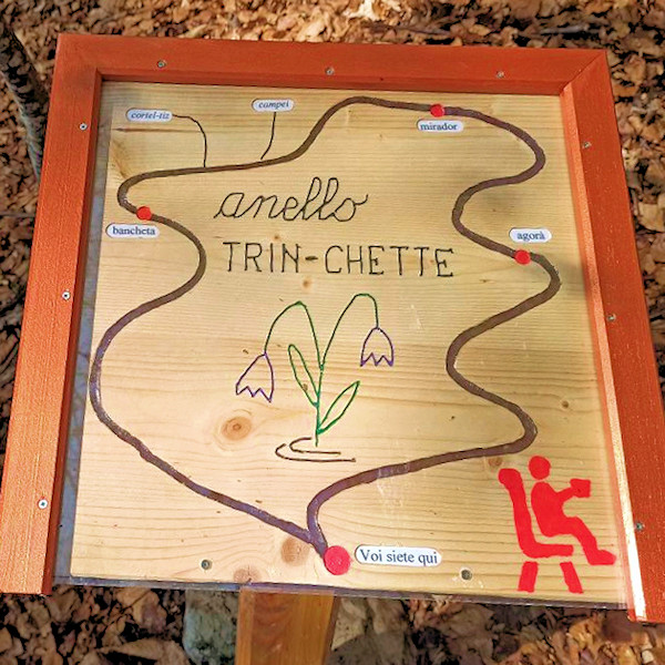
The notice board describing the entire route
For those who want to have lunch in a characteristic refuge, it is worth reversing the route. One always climbs along the Sentiero delle oche (650), at the notice board, instead of going up towards the Agora', take the path to the left (signpost 'Bancheta'). After about 40 minutes of walking, you reach the Bancheta and ascend further up the steep path to the ridge. You turn right (towards NE) and shortly arrive at the signpost of the Mirador. Continue along the ridge, slightly downhill until, at an altitude of around 1380 metres, you cross to the left (N-W) for 60 metres until you cross path 650. Continue towards the valley until you reach a crossroads on a road and a sign indicates the ascent to the Malga Campei hut. Walk up the steep road for about 150 metres until you reach the hut, which offers a typical Trentino menu. The return can be made via path 650; in the event of bad or wet weather, we recommend following the Frugnoni forest road and then the Brentegana road until reaching Festa in about 1.5 hours.
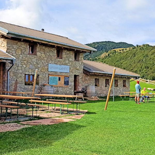
The friendly Malga Campei hut
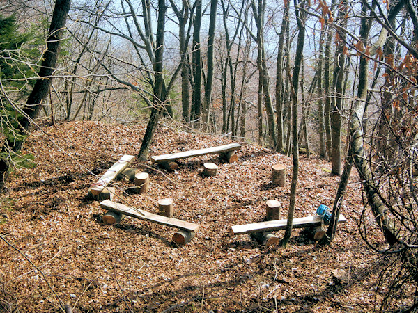
The path has been used since ancient times as a shortcut to reach the Campo da Festa hut on foot, avoiding the wide loop of the 'Goose Path'. In fact, the path takes place at the only accessible point between the steep rocks that plummet down to the plains of the village of Festa di Brentonico. The name of the path is due to the fact that at a panoramic point of the route, just before reaching the ridge, there was a bench, now almost destroyed by time and weather. A very scenic spot on the ridge was also known as 'Mirador'; the word in dialect expresses exactly the beauty of the place. Piero and Renzo, two local residents, had often walked the path; they also learned that in the area there was a fortification dating back to the First World War.
the Agora, a place of quiet, discussion and deliberation
They had the brilliant idea of linking the two and began the hard work of mapping out a loop route that would connect both the war remains and the Senter dela bancheta. Piero and Renzo were also eventually assisted by the group of citizens called "I mati dela Sorna' (The madmen of Sorna). The considerable workforce allowed for the laying of numerous signposts, signs on trees, the construction of the benches in the 'Agora' and also the cleaning of all paths. The most onerous work was the transport of the new bench to the 'Bancheta' area and a table from Malga Campo; a bench was also built in the 'Mirador' area. Very interesting are the remains of the First World War: this was an observatory over the Adige Valley. A plateau housed the soldiers' barracks, there are still the remains of stairs, masonry and a stone drinking trough still intact. The guard post consists of a tunnel at the end of which a window looks out over the Brentonico plateau and the Adige valley. If you want to enter the tunnel, you must climb the path up to a hump and then climb in a very exposed traverse (caution!). Four benches have been built on the plateau, and when we saw the ring-like arrangement, it it came spontaneously to call the place by the name of "Agora'". Recall that in ancient Greece, the city square was referred to by this name where the democratic assemblies of the citizens were held.
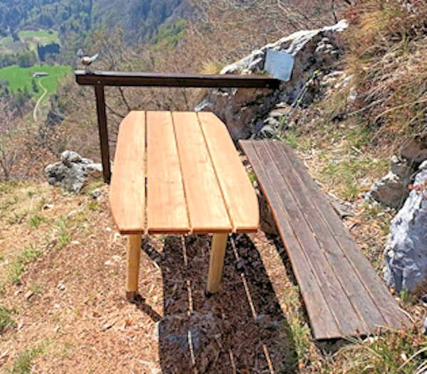
The historic bancheta and the new table
WARNING - The group of volunteer citizens called 'I mati dela Sorna' has worked hard to make the trek as safe as possible. Keep in mind that Monte Baldo is still a mountain and, as with all excursions in an alpine environment, it is not absolute safety cannot be guaranteed.
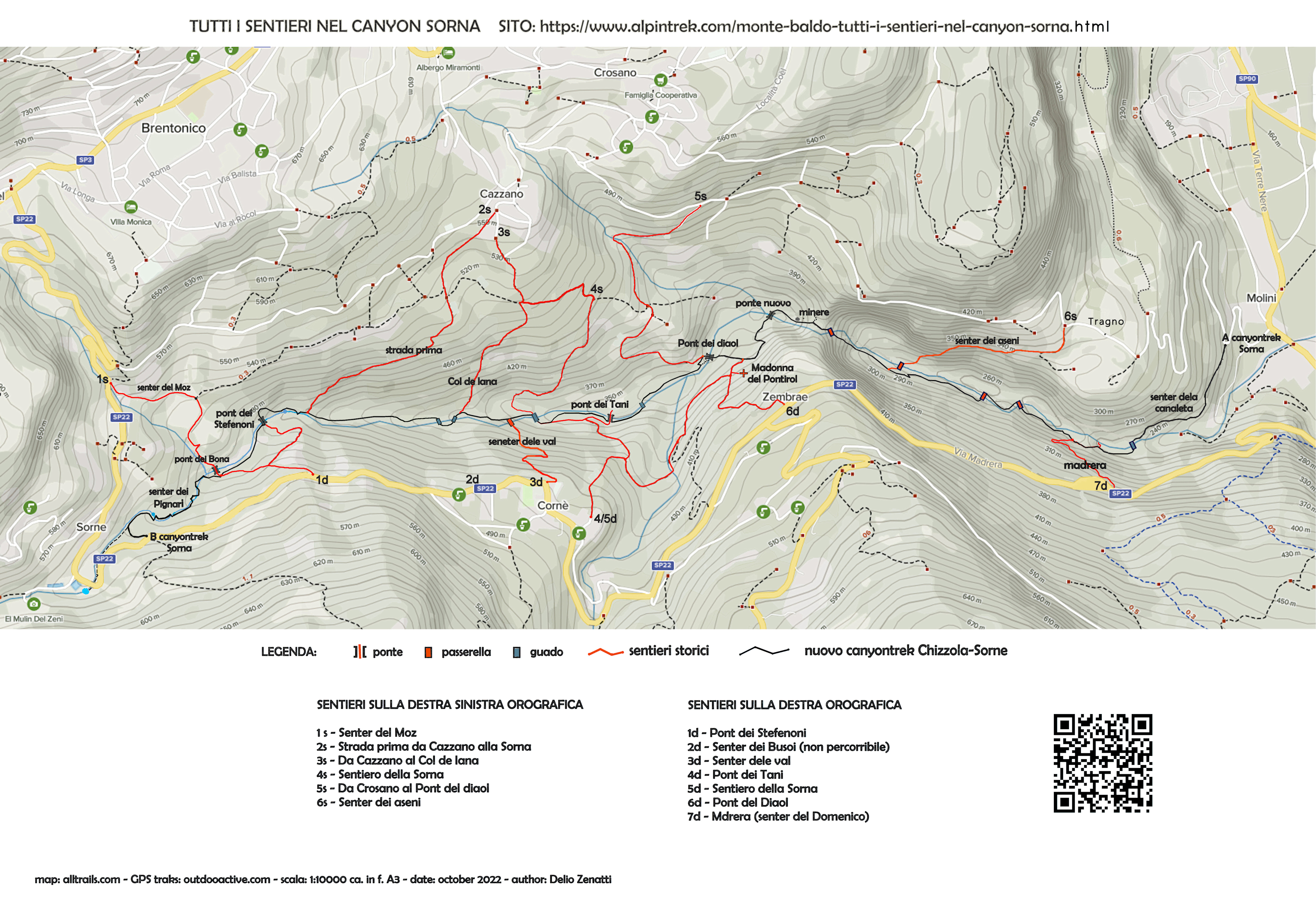
MONTE BALDO TUTTI I SENTIERI NEL CANYON SORNA - MAP CANYONTREK SORNA
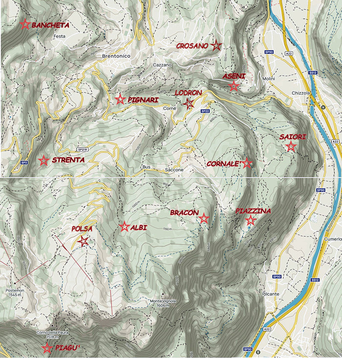
UNKNOWN PATS ON MONTE BALDO - SENTIERI SCONOSCIUTI SUL MONTE BALDO
CORNALE' - BANCHETA - PIGNARI - BRACON - ASENI - SAIORI - PIAGU' - PIAZZINA - ALBI - CROSANO - POLSA - LODRON
SOURCES - From outdooractive.com, you can also download the gpx file of the route.
Web site https://out.ac/I9BGSt
Alltrails.com maps - Delio Zenatti's gps tracks on outdooractive.com