![]() Brentonico voluntary citizens' group
Brentonico voluntary citizens' group
"I mati dela Sorna" of Brentonico
No address or telephone number
Please refer to the author
(logo by Aldo Ripamonti)
![]() Brentonico voluntary citizens' group
Brentonico voluntary citizens' group
"I mati dela Sorna" of Brentonico
No address or telephone number
Please refer to the author
(logo by Aldo Ripamonti)
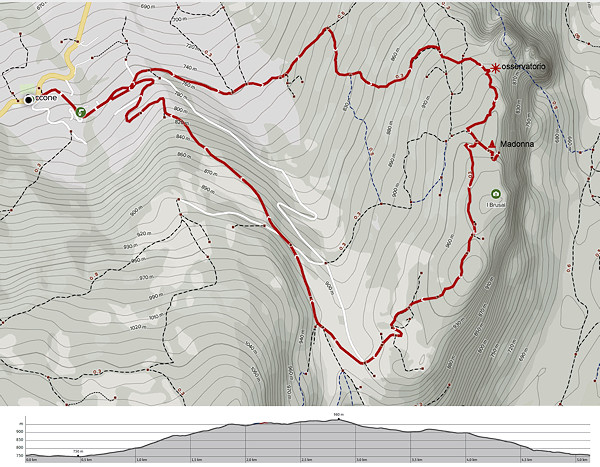
Park at the Saccone cemetery, the only place in the village suitable for this purpose. Climb up through the village to a
sign on the left and descend slightly to a fountain. Follow Via Furlani horizontally and eventually climb a steep slope, always to the east,
until you reach an opening called 'Orto'. Immediately to the right starts a path that, with a couple of steep climbs, leads onto a road that
leads directly towards Madonna del Cornale'. After about a hundred metres on the level, paying attention to the signs on the trees, you
take a path to the left, recently marked (June 2022). The path climbs up through a sparse wood, crossing a network of trenches and, after
about 200 metres, it leads directly to the entrance of the observatory. Climbing the dark staircase (stack) of the fort, you come out on the
west side of the Monte Cornale' ridge and follow the ridge southwards. After about 200 metres you see on the right (west) side a deep, angled
trench and there you begin to descend. You will soon reach the road that leads to the Madonna della Crona.
From the little church, it is worth going down the steps to the capital below the rocks, where a child fell many years years ago. From the
little church, go back about fifty metres until you see on the left (west) a path that, slightly uphill leads near the Cresta del Cornale'.
Follow the path to the south, which soon becomes a dirt road, until you reach the houses of the Pozza. Here, one could comfortably descend
to the asphalt road of Val dei Berti. More interesting, however, is to descend slightly westwards on a dirt road until reaching the first
house. Towards the right, a forest path starts that leads directly to Saccone, crossing the asphalted road that climbs towards the Mont
(pay attention to the signs).
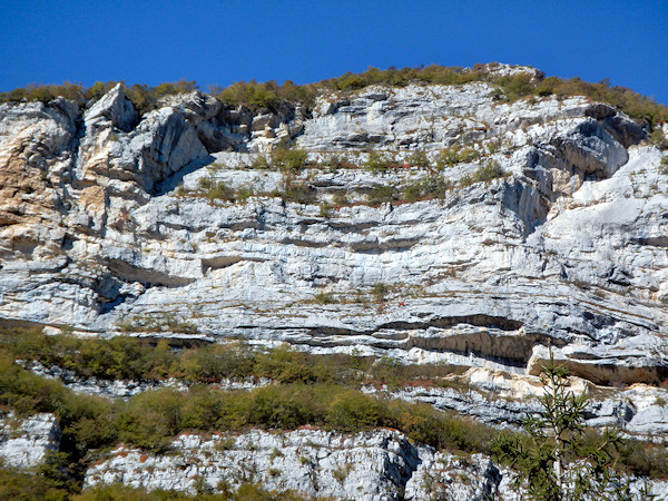
The imposing east face of Monte Cornale'
In the summer of 2016, some fellow citizens of Corne' have long been trying to find the famous Cornale' observatory, used
by Italian troops in the First World War. The accounts of those who had visited the place, long ago, spoke of a spiral staircase spiral
staircase that descended from the trenches into the depths of the rock to three separate chambers. It sounded like a fairy tale, until we found the
photocopy of a postcard from the year 1917 on which a large lighthouse was depicted and the inscription: 'Station 79C Cornale'. Surely some
local hunter knew the exact location of the blockhouse but there was a complete silence. Some fruitless searches followed on the ridge
of Monte Cornale' also searching by means of rope abseils. Following a more in-depth study of military strategy, the blockhouse, dug into the rock
rock forming the observatory, was finally located. It is first necessary to briefly set the history of the observatory in the vicissitudes of
the war on our territory. In the spring of 1916 the 'Straf expedition' (literally translated as punitive expedition) the Austro-Hungarians drove
the Italian soldiers to take refuge on the higher elevations of the Baldo chain. The Italians' counter-attack drove the Austrians to entrench
themselves in the Gresta valley while the first Italian line was fortified on the slopes of the village of Castione. The valley of Loppio
and the Adige Valley remained no man's land while the first line of the Austro-Hungarian army crossed the Adige Valley north of the town of Marco
and then climbed towards the Zugna and beyond to the Pasubio front. The exploits of the soldiers on Mount Pasubio where the armies faced each
other in bitter fighting that resulted in 10,000 deaths.
In our area, on the contrary, the situation was calmer for a simple tactical reason: whoever wanted to attack had to cross the wide valleys of
Loppio and Adige, exposing themselves, in the open, to enemy fire. The Italian positions on the Brentonico side enjoyed a relative tranquillity
and only suffered a few exchanges of cannon fire; the Italian soldiers were mainly employed in the construction of trenches.
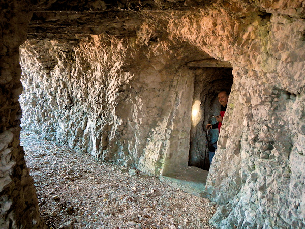
The inside of the Cornale' Observatory
However, there were some terrible bombardments on the village of Saccone by the famous 'Berta' cannon installed in
South of Rovereto and this caused the evacuation of the inhabitants. It is evident in this context the strategic importance of the slopes
of Mount Cornale', overlooking the Adige valley, and the Austro-Hungarian fortifications south of Rovereto. The Austrians' first line was
at Marco and then to the south the Italian railway reached as far as Ala bringing supplies and ammunition for the soldiers on the Cornale'.
A cable car carried supplies as far as to Piazzina where they were accumulated in a long tunnel on the 'Dos dei Lovri', now almost completely
destroyed. At night, long columns of mules transported the materials up to the crest of Monte Baldo, to the gun emplacements on Monte Altissimo
and also to the fortifications on Monte Monte Cornale', up to the first line below the village of Castione. The generals of the Austro-Hungarian
Empire decided to cut this line of supplies by means of air raids on the town of Ala. The planes took off at night from the airport in Valsugana
and dropped their bombs on the railway and the depots, passing right in front of the Cornale' ridge. The strategists of the Italian army
immediately realised the importance of the threat and had a very special fortress built on Monte Cornale', carved into the rock, which was
probably the first attempt at anti-air defence in history. Evidently the Austro-Hungarians were unable to attack, by land, either the railway
or the stores of supplies and ammunition depots in Ala, the only resource was air attack. From South Tyrol came what were the first bombers
in history to drop their grenades on the railway and the stores in Ala, naturally at night. The Italian soldiers found the remedy and built
what was probably the first anti-aircraft defence of the conflict: our Observatory. They dug a tunnel through the crest of the Cornale' and in
the middle of the tunnel a sinusoidal staircase descending to a blockhouse consisting of three chambers. In the central chamber was installed
a powerful mobile lighthouse on railway rails; from the photos it is possible to estimate the diameter of the lighthouse at 120 cm. The lighthouse
was powered by a generator located outside in a sheltered plateau that is still visible. The first side chamber to the south was a shelter for
soldiers and is still intact. In the room to the left and still visible on the window overlooking the Adige valley are the anchor holes of a
powerful machine gun and was partially destroyed by a cannonade. The strategy was so clear: the Austro-Hungarian planes were framed by the
powerful searchlight, powered by the power unit, and the machine gun opened fire. The searchlight was then withdrawn on the track, towards the
inside of the tunnel to protect it from enemy fire.
Extreme caution is recommended when visiting the fortress and climbing the dark inner staircase due to the danger posed by some unstable stones.
The entire route runs through privately-owned woods, so we recommend the utmost respect and not to leave traces of your passage.
It was in the spring of 1943, Arnaldo and Mario, two ten-year-old children had gone to the Cornale' ridges to collect a
particular grass that the cattle liked. The grass usually grows on rocks, in places exposed to the sun and danger. In the heat of the Arnaldo
stumbled and Mario saw him fall from the rocks; the boy ran to the village to raise the alarm and from Saccone some villagers set out to recover
what was believed to be a dead child. The recovery proved to be rather difficult because Arnaldo had stopped on the plants under an overhang
about 30 metres high; he was taken to hospital with some fractures and injuries but survived and later opened a business in Milan. The episode
was momentarily forgotten, but not by Arnaldo, who returned to his home town in the summer and had the intention of bringing a statue of the
Madonna to the site of his fall. The undertaking had the backing of the ecclesiastical authorities and the help of all the inhabitants, including
the including the Alpine soldiers of the Saccone section.
A capital was built in the middle of the rocks, and in 1981 a mass was celebrated on the plateau above in the forest called 'Busa della Crona'.
and to the Madonna was given the same name. It was soon realised that not all the people present were able to reach the chapel suspended on the
rocks and so the new venture was born to build a concrete staircase. A good mason named Aldo, assisted by his son Lionello, built the 81 steps
that still allow access to the capital today. The place became a place of pilgrimage until a rich lady with the material help from some pious
women of the village and also the offerings in money and works of many families, had the idea of building the small church.
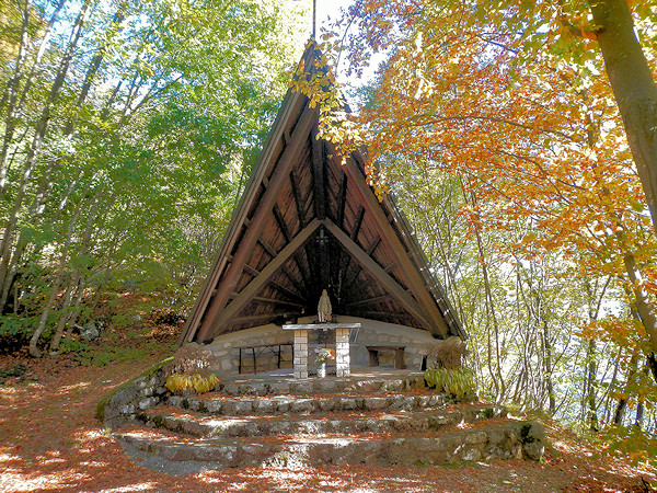
The small church of Madonna del Cornale'
WARNING - The group of volunteer citizens called 'I mati dela Sorna' has worked hard to make the trek as safe as possible. Keep in mind that Monte Baldo is still a mountain and, as with all excursions in an alpine environment, it is not absolute safety cannot be guaranteed.
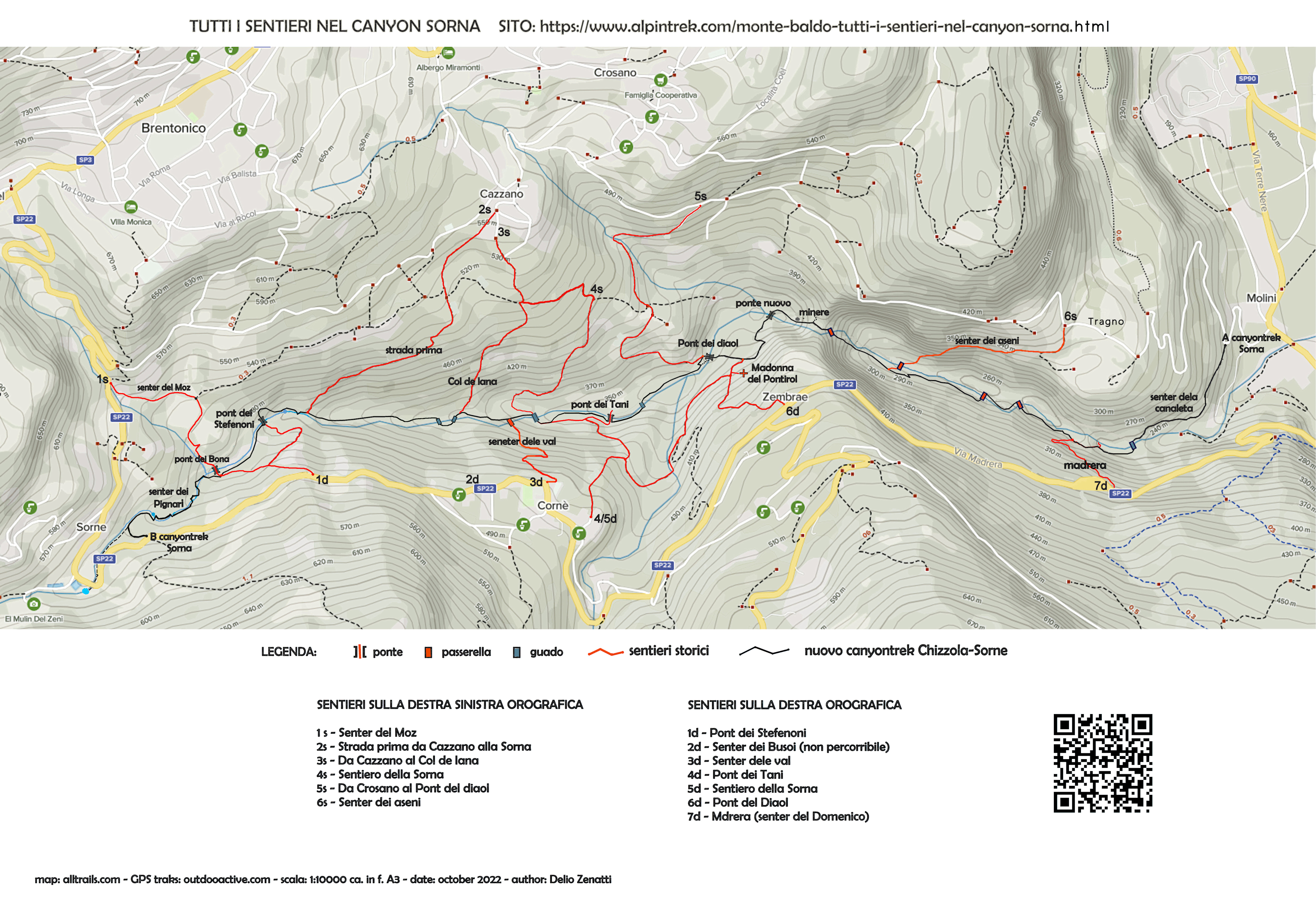
MONTE BALDO TUTTI I SENTIERI NEL CANYON SORNA - MAP CANYONTREK SORNA
UNKNOWN PATS ON MONTE BALDO - SENTIERI SCONOSCIUTI SUL MONTE BALDO
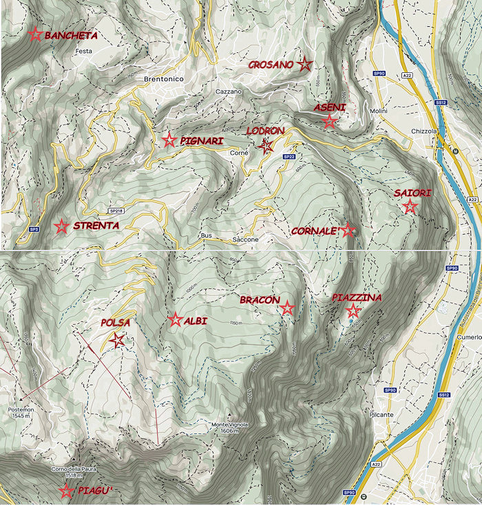
CORNALE' - BANCHETA - PIGNARI - BRACON - ASENI - SAIORI - PIAGU' - PIAZZINA - ALBI - CROSANO - POLSA - LODRON
SOURCES - From outdooractive.com, you can also download the gpx file of the route.
Web site https://out.ac/ICcMcc
Alltrails.com maps - Delio Zenatti's gps tracks on outdooractive.com